About Iguazu Falls—
The thunderous roaring of these fall can be heard from miles away.
The name Iguazu comes from the Guarani words y (water) and guasu (big). The legend says that a god planned to marry a beautiful aborigine named Naipí, who fled with her mortal lover Tarobáin a canoe. In rage, the god sliced the river creating the waterfalls, condemning the lovers to an eternal fall.
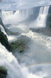
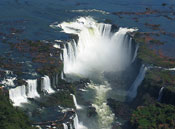
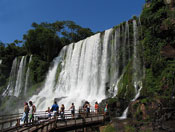
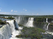
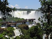
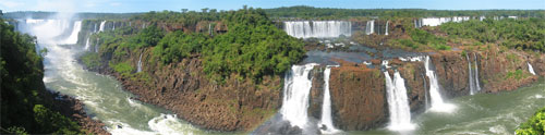
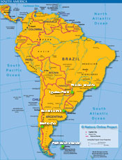
This magnificent array of waterfalls is located in Southern Brasil in the state of Parana on the border between Argentina and Brasil. They stretch for 2.5 miles plunging 269 feet (82m) into Iguaçu River. Numerous rocky and wooded islands on the edge of the escarpment over which the Iguaçu River plunges divide the falls into some 275 separate waterfalls or cataracts.
The falls are shared by the Iguazú National Park (Argentina) and Iguaçu National Park (Brazil). These parks were designated UNESCO World Heritage Sites in 1984 and 1986, respectively.
There are two main towns on either side of the falls: Foz do Iguaçu in the Brazilian state of Paraná, and Puerto Iguazú in the Argentine province of Misiones. Other important tourist attractions near the falls include the Itaipu hydroelectric power plant, and the Jesuit Missions of the Guaranis in Argentina, Paraguay and Brazil.
The Garganta del Diablo ("Devil's Throat"), a U shaped 150 meters wide and 700 meters long cliff, is the most impressive of all, and marks the border between Argentina and Brazil. Most of the falls are within Argentine territory, but from the Brazilian side (600 meters) a more panoramic view of the Garganta del Diablo is obtained. Many Islands split up the falls, including several large ones.
The vegetation of the region is rich and varied, ranging from semideciduous to tropical. Contrasts are also abundant, with orchids growing next to pines, bamboos next to palm trees, and mosses next to lianas and colorful begonias.
|